Staple Rights
The biggest point of dispute between the city and the ‘Ommelanden’ was the so called ‘Staple Rights.’ Settlers of the ‘Ommelanden’ were obligated to trade their grain in the city and were allowed to brew beer for personal use only. Opposition against the Staple Rights increased and eventually in 1575, the Ommelanden seceded from the city. In 1579, the Ommelanden signed the Union of Utrecht and joined the Calvinist rebellion against Spain.
Member of the Republic of the United Netherlands
However, secession did not last long. In 1594, the combined armies under prince Maurits and Willem Lodewijk, Earl of Nassau, captured the pro-Spanish Catholic city Groningen. In 1594, in the so called ‘Traktaat van Reductie’ (Treaty of Reduction) the States General determined that the city and the Ommelanden were to be united into one ‘Gewest’ (region). On 17 February 1595, the city of Groningen and the Ommelanden were admitted to the Republic of the United Netherlands as the seventh province.
The Provincial Council of the ‘Stad en Lande’ made up the General Executive Government of this new region, which was comprised of the Mayor and Council of the city of Groningen and the States of the Ommelanden. Both parties had one vote. The Provincial Executive made up the executive committee. The highest ranking Provincial administrator was the ‘Stadholder’ (regent). His most important post was Captain-General of the armed forces in the region.
French occupation leads to new government structure
During the French occupation (1795-1813), the Batavian-French period, the Dutch governmental organisation was fundamentally changed. Napoleon laid the foundations for the governmental organisation as we know it to this very day. The Departments in The Hague wield the scepter. The borders and name of the current province of Groningen have changed several times during that period.
It was called ‘Westereems’ during 1799 and 1801 with Leeuwarden as its capital. This was later replaced by the Department of Groningen. In 1811, a Department of Westereems was formed. The Department of Westereems was comprised of the current provinces of Groningen, Drenthe and the area between the Eems and the current state border. For the first time, municipalities were established which was an important new development. Since 1808, some 62 municipalities have been established in the province of Groningen.
The Departmental Board is made up of twelve persons whose sole respons ibilities are to collect taxes and improve infrastructure. Since 1807, the ‘landdrost’ (préfet) is the highest ranking provincial administrator. Six assessors (sous-préfets) assist him.
Kingdom of the Netherlands
In 1814, the domination by the French came to an end: the Kingdom of the Netherlands was founded. The Departments were replaced by the Provinces. The powers of the Provincial Council are described in detail in the Constitution. The king appoints a governor for each province who will have a deciding voice in the State Executive. He has direct access to the king.
The members of the Provincial Council are elected by a group of men who pay a certain amount of land taxes. This is known as census suffrage. There are about 450 electorates on a total population of 145.000 people. They vote for electors who in turn vote for the members who will make up the Provincial Council. The democratic role of the Provincial Council at that moment is relatively small.
The Province Law of Thorbecke
The new Province Law of 1850 was based on the Constitution of Thorbecke (1848) and helped secure the future of democracy. From that time onwards, the province was allowed to levy its own taxes and issue regulations. State meetings became public, however, only the most well-to-do men could vote for State members. In 1917, universal suffrage for men was enacted, followed in 1919 by women suffrage. This effectively marked the end of census suffrage.
A dark chapter in the history of democracy during the Second World War
During the Second World War (1940-1945), the provincial Government functioned until 1941. On September 1, 1941, regulation 152/1941 took effect. This meant that all activities both of the Provincial Council and the municipal councils were postponed. This was the end of parliamentary democracy. The Provincial Council was obligated to end all its activities. The Queen’s Commissioner was fired. All delegates were forced to resign. They were replaced by six Governing Counselors (members of the NSB, the Dutch Nazi party). In February 1942, a member of the NSB was appointed as Provincial Commissioner by the German occupiers.
From the post-war period until now
A new time of change dawned after the Second World War. It was yet again possible to hold elections for the Provincial Council. In 1962, a new Province Law was enacted. The Provincial Council received more tasks and powers.
Dualism was established after the State elections of 2003. The delegates were no longer members of the Provincial Council. The members of the Provincial Council have become representatives of the people and also check the supervisory board of the Provincial Executive.
Would you like to know more?
Do you want to know how everything is organised right now and who are seated in the provincial Government? For more information please check the link for the Provincial Council & Provincial Executive. We have put together a brochure called ‘de Statenzaal,’ describing the history and management the Provincial Executive of the past four centuries. You can request this brochure or download it here below.
Fort Bourtange -
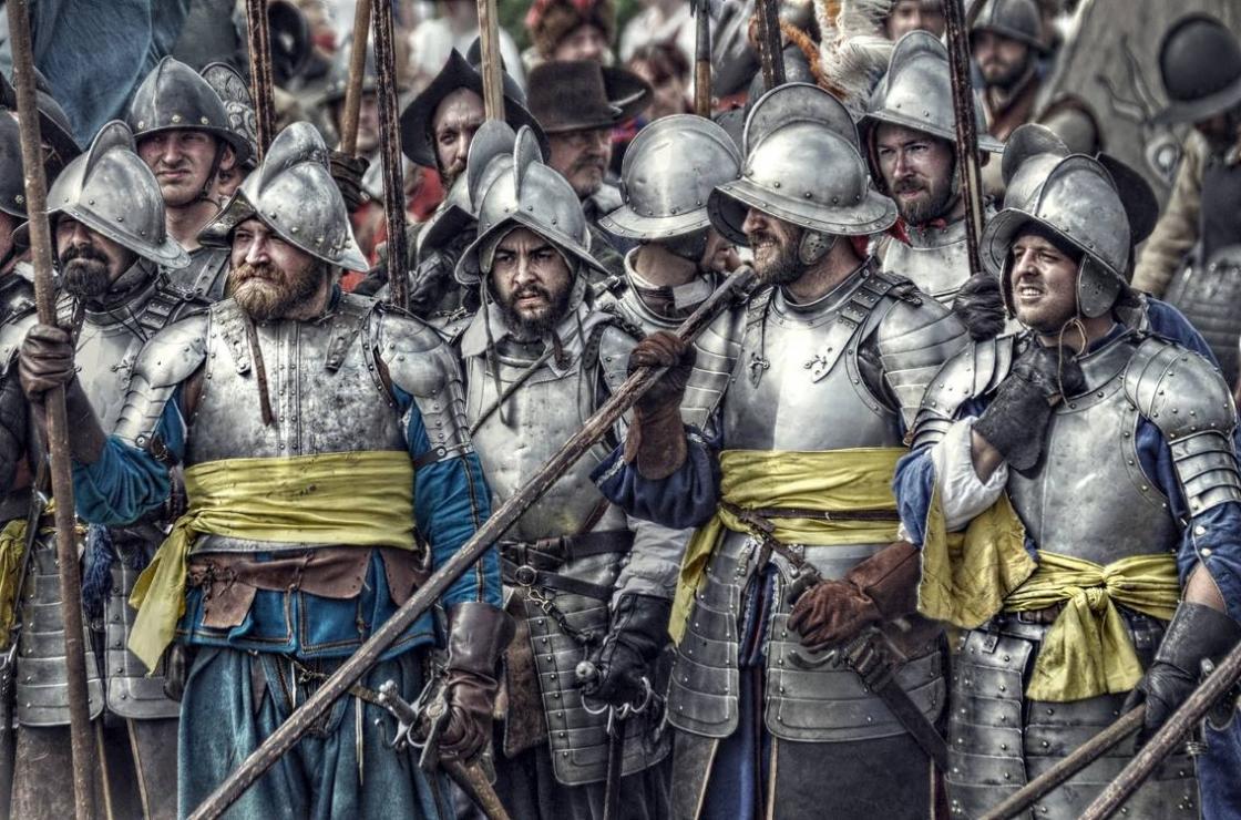
During the Eighty Years' War (1568 - 1648), the Spaniards had control over Groningen and the road leading from there to Germany. William, the leader of the Netherlands, saw it necessary to break off communications between Groningen and Germany. He decided that it would be optimal to build a fortification on the Bourtange passage, which was the main road leading to Germany. The fort was completed in 1593 in the design of a star fort with a network of canals and lakes which were used as moats (which were also constructed in the design of stars). At the time of its completion, the fort housed five garrisons. Soon after its construction, Spanish forces from Groningen besieged it, though the attack ended in failure.[1]
Fort Bourtange faced another battle in 1672 against invading forces of the Prince-Bishop of Münster, France's German ally in the Franco-Dutch war. After capturing 18 cities and towns in the northern Netherlands, they demanded that the Fort be surrendered. The fort's governor, Captain Protts, refused this demand, and the Münsters replied with a frontal assault. Thanks to the surrounding marshes and the time-tested fort defenses, the invading army was repelled successfully.[2]
After its eventual secession and conversion into a village in 1851, living conditions began to deteriorate. Over 100 years later in 1960, the local government decided that to combat this growing problem the old Fort would be restored to its 1740–50 appearance and made into a historical museum. This provided valuable tourism for the surrounding village. The Fort remains a museum today.